Day 19: A portage to nowhere, and we get sad

It was sunny when we woke up, and we had a goal: plot a portage route as far as we fucking could. All six (or seven? three? who knows) miles to the Daaquam if we had to, depending on what the water looked like. It finally felt like we had a plan underway and might be able to make some headway.

It was not to be. About a mile from our camp in the logging slash we ran into impassable swampland. We couldn’t even WALK through, much less get the canoe through over waist-deep water and miserable nests of downed trees. The only upside was that there are a few decent spots to put in after the current set of rapids, and we can’t see or hear more after that point, so theoretically if we can get the canoe to there we can at least get a mile or so down the river before potentially having to pull out again.

Even though it was only about 2:30 in the afternoon when we admitted defeat, we dragged ourselves out of the swamp and back to camp and crawled into the tent completely dejected.

Every time we think we’re going to catch a break and make some decent headway, we run into a wall. We knew going into this that this trip would probably be the hardest thing either one of us had ever done, but I think we both thought the tough part would be the Bay of Fundy… which at this point, we’ve had to accept that we’ll never make. This is some Lewis and Clark level shit and we’re both pretty disheartened at the moment.

On top of everything else, the roar of the rapids has been increasing since we began. At the headwaters, it was the rush of the dam. Every site after that, it’s been the rapids we’re currently struggling to get past. I wake up to it and fall asleep to it every. Damned. Day. There’s no escaping the constant reminder of water we can’t paddle and it is MADDENING.

In addition to making you feel like you have TV-static tinnitis, having this in the background 24/7 means you CONSTANTLY have to pee.

We came out here looking for this type of challenge, so even now I’m not really complaining; there is nobody I can think of that I’ve ever known (save MAYBE my batshit nuts aunt Laurie, who once dump-tackled a drugged-out stranger who tried to steal her backpack in South America) who has done something quite like this. People start the St John and Baker Lake because it’s easier, and they get out around Allagash because that’s an easier end than doing the rest of it. This way makes the St John still feel wild and powerful, not like a sporadically-runnable guidebook attraction. If we had wanted easy, there are a hundred paddling trips we could have done instead that would have involved WAY less effort and misery.

Note to self: find and read more journals of explorers and see if I can read between the lines to find the days where their true feelings are “fuck this, fuck nature, fuck the map, fuck the boat, fuck all of it, we should have brought more alcohol”.
Day 20: WE PADDLE! …and then don’t

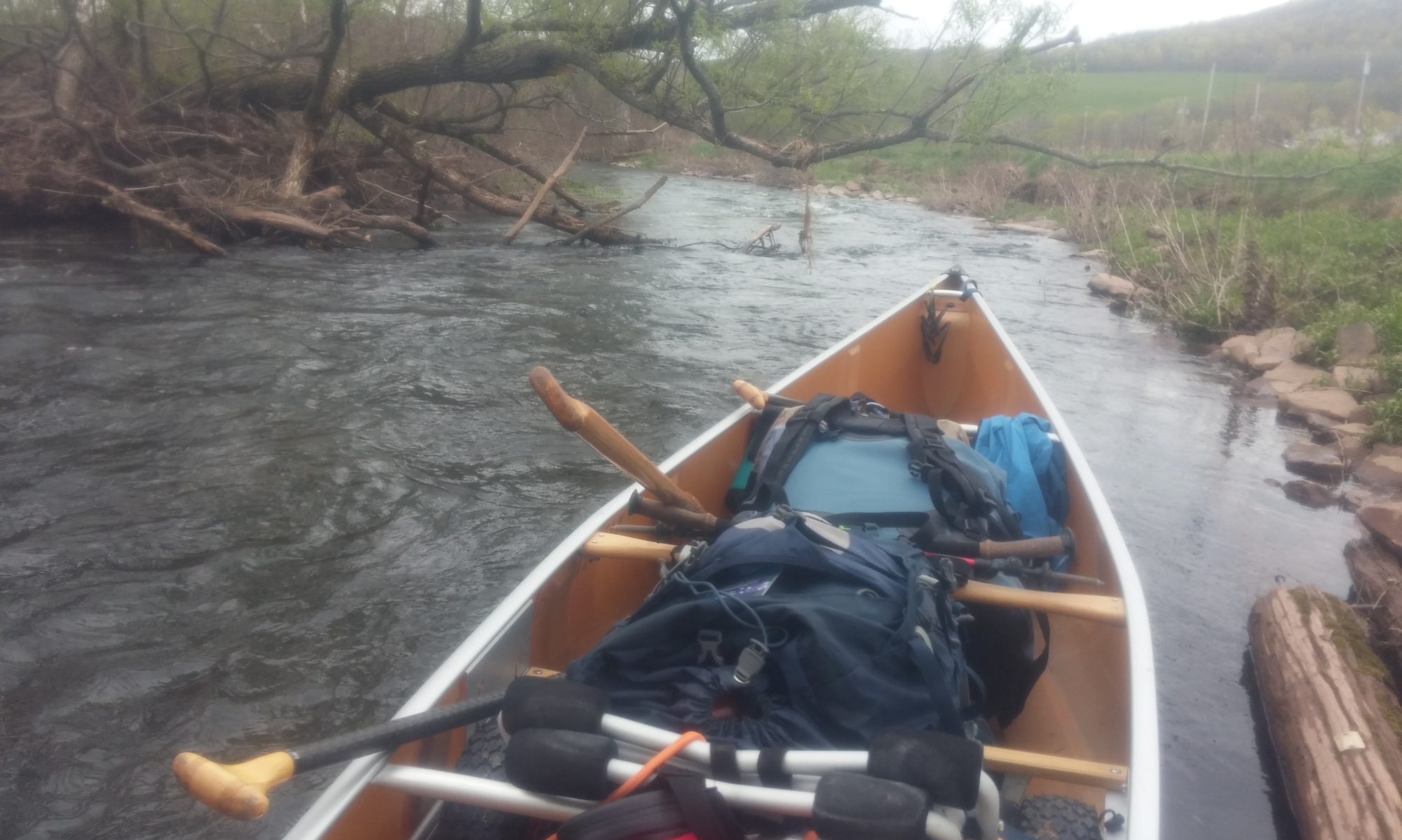
Against all odds, it was damned nice outside when we woke up, so we were up and about early hauling the boat down to the portage route we’d scouted out yesterday. It became clear pretty quickly that we wouldn’t be able to get as far as our original intended put-in; the snow was rotting away underfoot and the terrain was much too varied to safely waddle through with portage packs and a boat.

By the time we got the gear loaded we had gone back and forth a few times about the merits of putting in directly and IMMEDIATELY negotiating some class I+ rapids at high speed vs. lining the boat a hundred yards downriver first.

We lined it. (Sorry, Steve. I know you wanted to hit that run.)

And then, believe it or not, WE GOT IN THE CANOE. AND WE PADDLED. And the SUN was SHINING, and we saw a DUCK, and EVERYTHING WAS GLORIOUS. (Ducks have always been good omens for us. Refer to the Delaware paddling journals for proof.)

…And that lasted all of ten minutes. We made it maybe a mile, then heard fast water.

LOUD fast water.

We couldn’t see anything; the river looked like it continued straight forward and then just… disappeared.

Then we saw a splash of water shoot six or seven feet into the air, and Steve pulled us over so fast my face got rammed into a whole series of overhanging trees.

We tied off the canoe in a chest-deep cedar swamp (in normal water levels, it’d probably have been a lovely dry stroll) and carefully waded to a point where we could climb ashore, then bushwhacked down to check out what turned out to be a hundred yards or so of some of the gnarliest boat-eating rapids I’ve ever seen in person.

DAMN IT, NORTH WEST BRANCH.

The river dropped over a six-foot ledge at the top, then boiled over and around boulders bigger than my car to create massive standing waves. There wasn’t a calm eddy as far as we could see; the entire surface of the river was whitewater. Underlying the unceasing roar of the water was the low grinding of rocks along the river bottom, and periodically a piece of lumber dislodged by the ice floe sailed through at a speed most trees can only dream of.

Honestly, it looked like the kind of thing that might be sort of fun (albeit terrifying) with a rubber raft and a paid professional doing the steering; unfortunately that’s just not the kind of water you take on with seven weeks’ worth of gear and a kevlar canoe.

The horizon is level in this photo. That’s just how hard the river is losing elevation here.

Despite the soul-crushing discovery that we were going to have to take out and portage AGAIN, we miraculously stumbled through the dense underbrush onto a moose track… which led us to a logging slash… which dumped us onto a very much out-of-use but perfect-for-our-purposes LOGGING ROAD. It paralleled the river and spit us out at an AMAZING campsite on DRY GROUND (not solid snow, not ice, not downed trees, but actual honest-to-God dry ground and pine needles), and after wandering around in the woods for a bit we found a nearly completely clear path between the campsite and our pull-out that allowed us to hike our gear a mile downriver to set up basecamp without either of us getting punched in the face by a tree. (At this point we’ll take even the smallest of things as a victory.)

The goal for tomorrow is to haul the canoe to this new, dry campsite from its safe haven upriver at the edge of the cedar swamp. It’s significantly easier walking than any of our portages so far, but the canoe is still 18.5’ long and wasn’t designed to be threaded between the dense evergreens of the Maine wilderness, so what takes us half an hour in backpacks will probably take us most of the day with the boat.

We’ve got a week’s worth of food remaining if we plan to maintain a respectable caloric intake, and we know the confluence to Allagash could potentially take us four days. This means we’ve got about two days to reach the confluence with the South Branch of the St John before we’re floating down to our resupply on fumes.

BUT. For right now, we’re camped on level dry ground on a ledge overlooking the river. Our stuff is dry, the gentle sound of water against the shoreline is louder than the rapids in the background, and I’m going to sleep like the dead next to my best friend in a spot that probably hasn’t seen humans in over a decade. Things aren’t all bad today.

You know what you DON’T see in this photo? A fucking SNOWBANK.

Plus, you know, I saw a duck, so that’s cool.

Day 21: (Marginally) easier portaging

Don’t get me wrong, I am ALL FOR wilderness and extremely remote untouched natural beauty. I love the idea of it existing; I love occasionally stumbling across bits of it; I love fighting for its preservation and always will and continue to believe in having to do things “the hard way” if you want to witness some of the wonders that exist in nature.

Speaking of wonders, CHECK OUT THIS SLIME MOLD that I definitely poked with a stick!

HOWEVER. I’ll be damned if this logging road wasn’t the most beautiful things I’ve ever laid eyes on. Thank you, International Paper or whoever manages this stretch, for the small amount of misery you have lifted from our shoulders.

That said, our portage from the swamp above the boat-eating rapids was anything but a walk in the park. The water has gone down about a foot (which was disappointing, since we failed to get any photos yesterday to showcase the true horror of the situation) so retrieving the canoe was a little easier, but getting the boat to camp still meant several hours of brutal physical labor hauling it out of the swamp, up moose tracks to the logging slash, and over a mile down a road that hasn’t seen use as a road in at least ten years and as such had quite a number of small trees growing in the middle of it.

If you’re not intimately familiar with a wilderness portage, it goes a little something like this: Drag. Stop. Lift. Carry. Lose sensation in your fingers. Stop. Lift over a log. Stop. Climb over the log. Lift. Carry. Stop. Put wheels on. Drag while partner lifts back end over substantial debris. Stop. Encounter snow. Remove wheels. Drag. Encounter swamp. Climb into swamp, pull canoe in. Float for ten blissful (frigid) yards while partner scouts exit strategy. Repeat, ad infinitum.

Canoeing is a hell of a lot harder when you can’t just keep the boat in the river.

The good: beautiful, clear sunny day with a nice breeze- even though it’s COLD. The bad: we still don’t reeeeeeally know how much farther we have to go/what the river conditions look like between here and the main confluence. The ugly: if we don’t get to at least the Daaquam junction tomorrow and/or make good miles from that point on, we could stand a legitimate chance of running out of food. (Our original plan was that our starting resources would carry us well into New Brunswick. Ice and flooding has thrown a bit of a wrench into that plan.)

As I write this, I’m babysitting our camp. All the gear is out on a line in the sun, including the sleeping bags, which is AWESOME because we smell BAD. Steve is legging his way down the logging road to see if he can figure out where we’re at and/or how far we can portage, or if we should put in where we’re at now. I’m bitterly resentful of the fact that my short legs and slow pace make me pretty well useless in the scouting regard, but as long as I keep doing all the cooking Steve doesn’t seem too bothered.

One last unfortunate note on an otherwise lovely (cold) afternoon: we’ve started seeing bugs. Specifically mosquitoes. Given that we’re still in long underwear and puffies (not to mention still periodically post-holing) this development seems like a real dick move on nature’s part.

Day 22: FREEDOM!!!

Steve’s report last night was that the logging road cut east and petered out in a swamp full of angry beavers, so we figured the best course of action this morning was to put in and hope for the best.

By the river gods’ good graces, we got it.

We woke up to a gorgeous sunny day and a complete collection of dry gear, and we packed up early and lined the boat over the last little spit of rapids below our campsite. We climbed aboard, said a prayer to the river spirits that we wouldn’t hit anything too big to run, and crossed our fingers that we might actually make it to the confluence.

SMOOTH. FUCKING. SAILING.

HOLY SHIT, WE’RE IN THE BOAT.

One or two minor rips around big rocks, and one or two blind turns that made us a little uneasy since we weren’t sure exactly where we were on the map, but otherwise GORGEOUS. Remote swamplands; evergreen forests lined with cattails and short mossy banks into the trees; a few young moose who were exceptionally startled to see us; ducks all around. THIS is the romantic wilderness paddling experience people envision when they plan this sort of thing.

Within an hour we’d connected with the Daaquam. We shrugged out of the top halves of our dry suits and revelled in the warm sunshine and our pleasantly quick cruising speed. Every so often one of us would break our happy contemplative silence by shouting “OH MY GOD. WE’RE CANOEING.”

Roughly two and a half weeks later than originally planned, we cruised into Ledge Rapids Camp at 1:15… having covered about thirteen miles in less than two hours. (Sometimes floodwaters are terrifying, and sometimes they’re absolutely magical.) We called it for the day, hung the dry suits up to air out, and parked it on the front porch of the cabin to relax in the sun and kick the rest of the scotch.

Just LOOK at this majestic beast. He hid this stupid shirt in the bottom of his portage pack for THREE WHOLE WEEKS just so he could bust it out in celebration.

I’m in shorts. We’re no longer worried about running out of food; there aren’t ice chunks in the water; all the rapids we’ve hit have been so far under water that they barely register as blips on the radar.

…and here I take the first possible opportunity to start applying sunscreen.

AND WE SAW PEOPLE!! Three guys in a pair of boats stopped in to sign the register, and one of them was a local river guide who made helpful notes on our maps and told us that everything from here to Big and Big Black Rapids should be no big deal at these water levels. They had a fresh weather report: clear and sunny for the next three days. BRILLIANT. He also let us know there were beds available at his family’s bunkhouse/restaurant in Allagash (the Kelly Camp and Two Rivers Lunch) if we wanted to splurge for a night or two once we got downriver.

All of this would have been amazing from a normal viewpoint, but given the three weeks of absolute hell we went through to get here this is downright SUBLIME. We’re both so happy/relieved/grateful to be here, to have each other’s company, and to be in this delightful weather and stupidly pretty scenery.

This cabin seriously felt like a 5-star hotel after the last three weeks of swampy snowbank tenting.

OH MY GOD. WE’RE CANOEING.

Day 23: We’re on vacation now

At this point we’ve made the transition to feel like we’re on vacation instead of in some sort of semi-frozen purgatory.

After a surprisingly mouse-free night in the Ledge Rapids cabin, we woke up to another cloudless day. Faced with a quick current and the choice of big miles or small meals, we set a lofty mileage goal of 46 and an ending point of the Big Black campsite well downriver. This would put us through Basford Rips and the Big Black Rapids, two of the three spots we were mildly concerned about.

It’s a good morning when your biggest dilemma is running low on sunscreen for your pasty gams.

The morning started with a lovely pot of coffee in the sun on the porch and an aggressively-close helicopter flyby (more on that later). We got on the water around 10:30; later than we’d hoped, but after catching up to and passing the gentlemen we’d met the previous day within the first two hours, we calculated our cruising speed at eight miles per hour and didn’t feel too bad.

Overall the paddling was spectacular. The scenery is stunning; trees, untouched riverbanks, a handful of pristine campsites, vast expanses of marshland full of birds and gently waving grasses. Periodically we come across a stretch where the ice floe is still on the bank, six or seven feet above the water line. THAT is always a little eerie, especially knowing we’d been in the water with some of those chunks of ice a week or so earlier.

It’s fine. It’s not like those are the size of my couch or anything.

As promised, the rapids we passed weren’t anything to worry about in high water; we bounced over them easily and didn’t give anything a second thought… until we came to the turn for Big Black and realized we were too far left to follow the line recommended by our guiding friend.

Waaaaaaayyy too far left. It was only big standing waves, but we took on a bunch of water in the first one we hit. As Steve morosely yelled “OH GOD. IT’S OVER. WE’RE SINKING. IT’S HAPPENING” and I laughed hysterically, we slowly and inevitably swamped. The swim to shore was cold but short and we didn’t lose a single piece of gear, so our spirits were soggy but high as we bailed the boat out on shore.

We coasted into the Big Black campsite midafternoon (having CRUSHED our 46 mile goal in about six hours) and were met by a group of seven or eight old timers who had been running the trip every spring for years (43 of them, in fact!) and were kind enough to feed us a bunch of their leftovers (Beans! Brown bread! Bacon! Steak! Cookies!) while telling us bad jokes and stories about their canoe racing experiences. Bob and Terry were the ringleaders of the crew; Bob and Terry, if you’re reading this, I’m sorry I never managed to track you down to thank you again for your hospitality. You guys rock.

The group had a campfire going (the first of our trip!) so we sat around well into the evening with them drinking chaga tea and trading stories, then got to pass out on dry ground in a dry tent smelling like wood smoke after a very satisfying day.

Day 24: A day that ends in showers

Bob and Terry’s group was packed and on the water well before we were (understandable, since they’ve got 40 years of practice on us) but we did join them for breakfast of hot coffee and pancakes. Since they were a day shy of being back in the frontcountry they unloaded a good bit of excess food on us- specifically a Mainard marvel called “macaroni loaf” which sounded gross but turned out to be just about my favorite meal of the entire trip. Someone also left a bar of dark chocolate in my hat as they departed, sealing their reputation as some of the greatest people we’d interact with for the entire trip.

Half of this photo is Canada, and if we landed there we’d be sent to federal prison. We had a lot of in-depth discussions about the nationality of local wildlife.

The river was quick and made up for our ponderous start, and the weather was clear, sunny, and warm. I have already begun the laborious process of the thrice-daily sunscreen application in the hopes of saving my flesh from the giant fireball in the sky.

Well hello there, scruffy moose friends!

The only rapids we had to worry about were the aptly-named three-mile-long Big Rapids just before Allagash. We figured we might not want to run it, and knew that if we missed the last pullout we were pretty much screwed. Three miles is a LONG swim if you dump.

We stopped around 1pm just above what we were pretty sure was the last turn before Big Rapids. Since it was super windy and the canoe kept trying to depart on its own, I stayed with the boat on a sandy shoal and Steve took a walk to see what he could see. An hour later (I threw a lot of rocks in the river while waiting) he returned with mediocre news: we’d missed the actual pullout, we WERE just above Big Rapids, and we could technically get out a quarter mile on but it would very much be on someone’s private (and posted) land. He could see the first tiny bit of Big Rapids and it didn’t look THAT bad, but it still left 2+ miles of gnar that we knew nothing about.

We ended up opting to backtrack the quarter mile upriver to the official launch to keep our karma balance intact. It was a miserable slog lining the boat along steep, slippery, thorny terrain and we were both a little cranky by the time we got there. It wasn’t helped by a shitty uphill portage of multiple miles that required wearing our 115L portage packs while dragging the canoe.

Via sheer dumb luck we ran into two guys with a truck who were dropping a rig off for their kids’ canoe trip, and the pair (Dean and Don from Fort Kent) offered us a lift into Allagash. HELL YES.

We loaded the boat (and Steve) into the bed of the truck and bounced down the road into Allagash. Even though the road was high above the level of the river, we still got a decent look at the rapids and felt pretty good about our decision not to run them. Since we’d already given up on the Bay of Fundy, we gave up on our “purist” tendencies and accepted a lift that skipped a couple miles of river and put us directly in the parking lot of the Kelly family camp in Allagash.

The aforementioned restaurant was closed for the afternoon, but we ended up renting a cabin for the night. Hot showers! TV! Wifi! A BED!!!

Sadly, a lot of the overwhelming joy at being back in civilization was sucked out when we discovered that an apparent mass panic among our friends and families had been directly responsible for the border patrol helicopter fly-by of the previous day, in addition to initiating the spread of a rumor among the locals that we were either a) fugitives from the law or b) complete moron tourists with no backcountry experience who “probably saw some movie with a canoe in it and thought this seemed like a cute idea”. To our credit, all the locals who ran into us had the same opinion of “wait, that’s YOU guys? But… you actually look like you know what you’re doing.”

It’s also worth noting that we stressed multiple times before we left that we were bringing several weeks’ worth of supplies, that there is ZERO CELL SERVICE in this entire area, and that the “you can start to worry” date was TOMORROW.

We recognize it was well-intentioned panic, but we’ve now eliminated a lot of folks from the list of who gets our float plans. It’s a lot harder to be sneaky about camping when literally everyone in a two hundred mile radius is trying to find your drowned corpse.

Day 25: ALL THE BREAKFAST FOODS

Few things are as satisfying as downing five people’s worth of hot breakfast after three weeks of dehydrated snacks. Hot coffee is an underrated godsend.

After explaining to LITERALLY EVERYONE IN TWO RIVERS LUNCH that NO, we weren’t on the run and YES, we were totally fine and NO, Steve was not holding me against my will in some weird brainwashing scandal, we launched from the Kelly Camp’s backyard. (Everyone was very pleasant about coming up to our table and grilling us mercilessly; we have yet to meet anyone in Maine that we don’t like.) We zipped down the still-flooded river through minor riffles and chilly temps despite the sun with an end goal of St Francis, where we’d heard there was a riverside campground via the Northern Forest Canoe Trail guide. (Their stewards were super helpful with a lot of camping questions we had on this stretch).

There was! Pelletier’s, run by a Norm L’Italien, who wasn’t immediately available. We took a stroll across town to find an ATM and then stuffed our faces with the world’s greatest homemade Boston Creme Pie at the Forget Me Not Diner while befriending the waitress.

So pretty! …and so cold.

Eventually we secured a campsite (and a bunch of cold beers, a first for the trip) and set up for the night planning on a relaxing evening playing cards at a picnic table while we waited out our dessert hangovers. However, the wind was so strong and so cold that we ended up piled into the tent playing drinking games in all our long underwear while the temperature dropped into the twenties. (Of all the gear we brought, the giant down quilt we affectionately call “The Big Squish” remains one of the best decisions.)

Hard liquor in plastic bottles: good to the last drop. (The VERY last drop.)

Day 26: Dinner AND a movie

That there is the self-satisfied smirk of a good-looking man who KNOWS it.

We absolutely CRUSHED the miles into Fort Kent. We had planned to paddle up the Fish River to the public boat launch by the blockhouse, but the Fish was VERY flooded and not having any of it so we pulled in behind a levee and walked into town.

This would technically be our LAST American mile of the trip.

Since the campsites at the end of the Northern Forest Canoe Trail were flooded out (the water had come down nearly 20 feet in the days prior to our arrival), we sent them an email asking about alternatives and checked in with local PD to see what our local camping options would be. While we were waiting for answers we horfed some sandwiches, made a solid resupply at the local Shop & Save, ate an absurd amount of Chinese food, and signed the NFCT registry at their “end of the line” kiosk. They had anticipated our arrival and left us a delightful care package of paddling trail magic, which absolutely made our day. Lacking other ideas, we even went to the movies for a viewing of “Supertroopers 2”, which was a very weird experience to have a) sober and b) after our recent interactions with border patrol.

The NFCT is definitely on our list.

The local cops put us in touch with Boy Scout Troop 189, who were absolute rock stars and allowed us to pitch our tent on the lawn of their Trading Post at the Fort Kent blockhouse and even use the Post’s bathroom. Given that their entire campground/picnic area/boat launch had been completely underwater mere days earlier, their troop had done an incredible job cleaning up in the aftermath of the flood. We had to drag the boat over the levee and through town since we couldn’t get up the Fish, but it was totally worth it.

It wasn’t open. We were bummed. But it was SUPER cool to camp on the lawn.

The weather is gorgeous, but everyone still seems to think we’re nuts for camping before Memorial Day.

Day 27: SPF 50, all day every day

Another glorious sunny day, which is much more acceptable now that we’ve restocked on sunscreen.

The silt line on some riverside shrubbery

The Fish punted us right out into the middle of the St John’s current and we cruised along comfortably. The paddling was uneventful save for the vast stretches where the water had been ten or twelve feet higher and left a thick layer of silt behind on everything it’d touched… in addition to full trees and the occasional roof.

Nothing to see here; just a tree that floated along and got stuck in the tops of some other trees.

We hit Madawaska about lunchtime and pulled over to eat at a small park. A quick jaunt up the railroad tracks and we picked up a couple of Lime-A-Ritas, which made for a VERY enjoyable float the rest of the afternoon.

The end goal had been a place called Thibodeaux Island, but the flooding had rendered it a swampy mudpit so we stopped nearby where a short and steep climb up a bank led to a lovely spot in a patch of reforested pines. We had chili mac, had a cold beer or two, watched the sun set through the trees, and got to spend a quiet night sleeping like the dead on a bed of pine needles.

Except, you know, for the adjacent highway. And train tracks. Aahhhh, nature.

Day 28: Another leg day

The sun continues! And we continue on into Grand Falls. The river crossed the border and is now fully in Canada; we stopped briefly at the first available Canadian customs station to “officially” cross the border, and they were completely nonplussed by our escapade. Seriously, when we rolled up to the drive-through on foot with the canoe, the Canadian officers were like “cool, okay, have a nice day, eh?”

Canada doesn’t seem NEARLY concerned enough about illegal Americans floating in; this was our only indication of having fully entered a new country.

River speeds slowed as we approached the dam, but the paddling was otherwise delightful. We pulled into the marina above Grand Falls around 4pm, discovered a restaurant/bar at the launch, and decided to have a burger while using their wifi to figure out our next portage/camping situation. The waitress was reasonably sure we could camp at the boat launch with permission from the town offices, but when we called them we realized we’d crossed into a new time zone without realizing it and their office was closed. We ended up calling the local police department, who said that even though it was closed we were welcome to camp at the “Chutes et Gorges” campground… on the other side of town, five miles away.

Dragging this down a US sidewalk always causes absolute mayhem. The residents of Grand Falls were completely nonplussed and all the pedestrians waved hello as if this was something they saw daily.

We got a HUGE break when the bar owner gave us and our portage packs a lift there and back in her car, but we still got to experience the joy of dragging the canoe down the entire main drag of Grand Falls. It was hellish, but worth it; the Falls were RAGING.

I mean, sure, it looks like the water’s a little high, but maybe down below it isn’t THAT bad…
YEAH NOPE IT’S DEFINITELY THAT BAD; you can see that the water level is so high it’s almost over the tops of the dam gates

Oh, and Steve got pulled over with the canoe.

I saw this happening from afar and was laughing so hard by the time I caught up I’d almost peed myself. They mostly wanted to make sure we weren’t putting in directly below the dam- you know, in that pile of whitewater from the previous photo.

The deserted campground was close enough to a Burger King that we ended up having second dinner and a couple of milkshakes before calling it a night. Bonus points for the nearby construction site that had port-o-potties.